- Рус
- Қаз
- en
About the park
 The "Buiratau" State National Nature Park was established on March 11, 2011 by the Forestry and Hunting Committee of the Ministry of Agriculture of the Republic of Kazakhstan within the framework of the implementation of the Zhasyl Damu 2011-2014 sectoral program with the support of the United Nations Development Program's Global Environment Facility (UNDP / GEF) "Conservation and sustainable management of steppe ecosystems".
The national park Buiratau (translated from the Kazakh - "Curly Mountains") is located in the transition zone between the sub-zones of moderately arid and dry steppes, which determines the uniqueness of the territory in the combination of steppe ecosystems with forest ecosystems (birch spruce, black alder).
The territory of the national nature park belongs to the second category of specially protected natural territories with the status of an environmental and scientific institution of Republican significance. It is designed to conserve biological and landscape diversity, to use the unique natural complexes and objects of the State natural environment for environmental, educational, scientific, tourist and recreational purposes - a fund that has a special ecological, scientific, historical, cultural and recreational value gt;
The objects of the SPNA fund are: forestry, geological, hydrogeological, geomorphological, zoological and botanical objects.
The park "Buiratau" includes the eponymous regional nature park of local importance, the territory of Belodymovsky and Ereimentau state nature reserves of national importance.
The park was established in the reserve lands and lands of the state forest fund of Temirtau and Erementau forestry institutions and is located in the Erementau district of Akmola region and Osakarovsky district of Karaganda region. It consists of two branches - "Ereimentau" (60 814 hectares) and "Belodymovsky" (28 154) ha). The total area of the national park is 88 968 ha. A guard zone with an area of 88,064 hectares is created around the park. The central office is located in the village Molodezhnyi, Karaganda region.
The territory of the national natural park "Buiratau" is located within the steppe zone in the transition zone between the sub-zones of moderately arid and dry steppes. According to the physico-geographical zoning of Kazakhstan, the territory of the national natural park "Buiratau" is included in the country Central-Central Kazakhstan shallow hills, the province of Karaganda-Chingiztau dry steppe low mountains and shallow hills, the Erementau-Karkaralinsky mountain- shallow hills area, moderately dry and dry steppe with high-altitude belt.
The main types of the relief of the national natural park "Buiratau" are the low mountains (hilltops), the low hills high (ridged), low (hilly and hilly-ridge), and various types of intermountain and inter-mountain plains - inclined, wavy, ruffled, flat. The characteristic elements of the relief are valleys of temporary watercourses, river valleys of small rivers and lake basins.
The territory of the national park "Buiratau" is located in the center of the Asian continent and therefore has a climate of sharply continental type. The influence of air masses from the arctic, temperate and southern latitudes determines the aridity of the spring-summer period, high summer and low winter temperatures, the insufficient and unstable yearly amount of precipitation with their summer maximum and significant wind activity throughout the year.
For the areas of the national natural park "Buiratau" as a whole, a large number of closed basins, mainly with salt lakes (Lake Azhbay and Bozaigyr) are typical. The depth of the lakes is small and on average does not exceed 1-1.5 m, the mineralization is significant. Waters of lakes are suitable only for watering animals. The main and most reliable source of water supply is groundwater, which forms artesian fresh water basins in the Carboniferous and Mesozoic Troughs, as well as fractured and fissured-reservoir waters with poor mineralization but small source rates. Within the mountains there is a dense network of shallow valleys and lairs with a temporary drainage formed during the period of spring snowmelt. On the small rivers (the Karabulak River), a steady flow occurs. At the same time, 70-90% of the annual runoff takes place over a period of one and a half to two and a half weeks in the spring, after which they become extremely shallow or completely dry. Fissured waters are widespread in quartzites. Underground waters are non-pressure and lie at depths of 1,1-17 m. At the foot of the slopes of valleys, along the logs there are outcrops of springs with a rate of 0.1 to 4 liters / sec. The quality of water is fresh. In general, the water availability of the territory is good.
In accordance with soil-geographical zoning the territory of the park is located within the subzone of moderately dry steppes with predominance of zoned dark chestnut soils. It is distinguished by the peculiarity of its constituent soil types and the complex structure of the soil cover.
The rarity and uniqueness of the park ecosystem is characterized by the following features:
• Presence of relic forms;
• medium degree of endemism;
• combination of species representing different ecosystems of fauna and flora, their diversity.
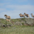
Prior to the establishment of the Sayratau SNPP on the basis of the regional nature park, also known as Buiratau, in 2001 an enclosure was constructed for keeping and breeding ungulates - the red deer (marals) with the aim of further reactivating them in the wild in the region of the National Park where they lived in the recent historical past.
A spacious aviary (400 hectares), allowing animals to eat natural foods for most of the year, winter feeding in accordance with established norms and diet, proper sanitary and veterinary supervision created good conditions for the habitation of the breeding herd.
The daily work of the national natural park "Buiratau", according to the approved work plan, is the protection of the natural fund, the holding of a complex of biotechnical measures to increase the biological capacity of natural lands and species biodiversity, research and environmental education activities, recreation and development of ecological tourism.